- Home
- ...
- Smarter Targeting of Erosion Control (STEC)
- Smarter Targeting of Erosion Control (STEC) News
Trees for slip prevention: reflections on STEC from an international PhD student
An increase in slip occurrence is often related to the loss of the protective effect of trees through deforestation. Methods of targeted reforestation, such as silvopastoralism, can reduce the risk associated with slips considerably while not negatively affecting pasture productivity. The effective implementation of such systems can benefit from guidance in terms of tree placement, planting density, planting pattern, tree species selection, and prediction of tree size. Computational models can help greatly, in addition to expert knowledge, especially on a regional scale. During my thesis a regional-scale model, called SlideforMAP, was developed to provide this guidance (van Zadelhoff et al. 2022).
Regional-scale modelling often poses challenges because of the variation in a range of relevant soil and hydrological parameters. We chose to explicitly include this variation as uncertainty in the model, which can improve the model’s performance. A strength of the model is that the reinforcement of the soil by each individual tree is included. Rigorous testing has found that soil depth, soil cohesion, and the ratio between precipitation intensity and the soil’s water conductivity are the most sensitive model parameters. SlideforMAP was applied to study sites both in Switzerland and in New Zealand to validate its performance.
SlideforMAP stands among other state-of-the art models, that consider vegetation effects on shallow landslide activity. This is due to the inclusion of single tree-based root reinforcement, the inclusion of parameter uncertainty, and tailoring to specific rainfall events. Further developments in SlideforMAP have enabled its application on large scales. Land managers can benefit greatly by applying models such as SlideforMAP to find the ideal targeted planting sites and stabilise the soil, as efficiently as possible from a cost-benefit standpoint.
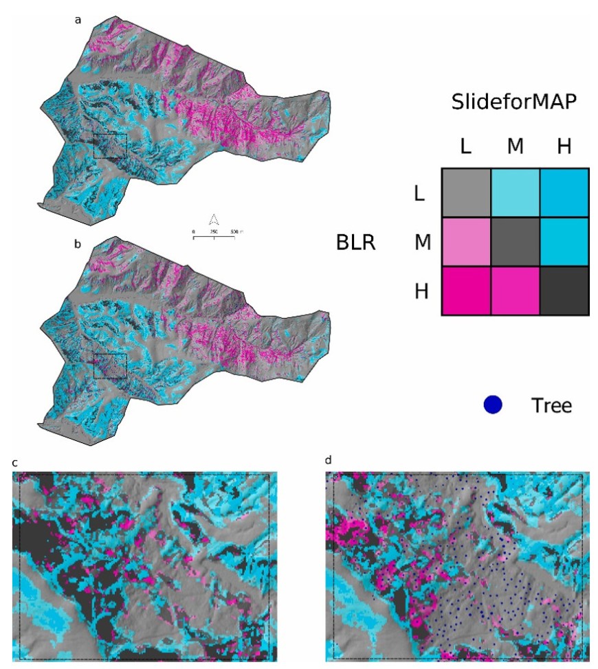
A highlight of my PhD was the comparison of the physically based SlideforMAP with a statistical model (BLR) for slip reduction by trees, also developed within the STEC project (Spiekermann et al. 2023). This comparison, applied on a hill-country farm in the Wairarapa, highlighted the features of each of the models and gave rise to specific recommendations on which model(s) to use, depending on the case at hand. Figure 1 is an illustration from the published paper comparing the STEC methods.

Figure 1. Difference between susceptibility classes from SlideforMAP and binary logistic regression (BLR). The legend is adapted to highlight areas where the highest difference is visible. The letters L, M, and H represent susceptibility classes of, respectively, low, medium, and high. Insert (a) is the difference without tree cover, and insert (b) is the difference under vegetation conditions. Insert (c) shows the zoomed window of the unvegetated scenario, and insert (d) the zoomed window of the vegetated scenario.
My PhD project gave me a broad experience in the use of modelling in erosion prevention through the strategic placement of trees. The interactions and exchanges in perspectives that I had during the STEC project were an enrichment that I look back on fondly. These exchanges also contributed to the incorporation of concrete ideas in the model development. I learned how much the accuracy of such modelling is dependent on the correct inclusion and understanding of the surroundings and the subsurface.
To contribute to a more complete understanding of erosion prevention and develop into a more well-rounded researcher, I aimed to become more experienced in modelling other aspects of the landscape. This is why I applied for a position in digital soil mapping, and I am currently doing a 2-year postdoc at Manaaki Whenua – Landcare Research in Palmerston North.
References
Spiekermann RI, van Zadelhoff F, Schindler J, Smith H, Phillips C, Schwarz M 2023. Comparing physical and statistical landslide susceptibility models at the scale of individual trees. Geomorphology 440: 108870.
van Zadelhoff FB, Albaba A, Cohen D, Phillips C, Schaefli B, Dorren L, Schwarz M 2022. Introducing SlideforMAP: a probabilistic finite slope approach for modelling shallow-landslide probability in forested situations. Natural Hazards and Earth System Sciences 22(8): 2611–2635.