Under predicted climate change scenarios these problems will worsen, as invasive weeds are likely to grow faster if there is more CO2 in the atmosphere. Storms are also predicted to be more severe in the future, creating greater disturbance and promoting weed invasions.
Manaaki Whenua’s Biocontrol and Molecular Ecology Senior Technician Paul Peterson and his colleagues have been working for decades on ways to reduce the negative impacts of invasive weeds in Aotearoa New Zealand (AoNZ) using natural enemies, and have recently started working in the Pacific Islands too.

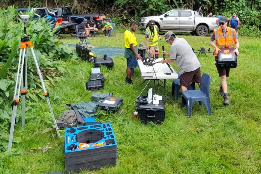
The team setting up drones in Rarotonga
“Introducing natural enemies to control invasive weeds in Pacific Island countries will often be the only practical solution to this growing problem,” says Paul.
Over the past two years Paul and colleagues have partnered with local government and environmental organisations in Niue and Rarotonga (Cook Islands) as part of a larger Ministry of Foreign Affairs and Trade (MFAT) funded project to develop natural enemies for key invasive weeds in the Pacific and to help countries to introduce and establish them.
This work was funded to develop a method to help better understand the extent of invasive weeds in the Pacific, and the impact of natural enemies being released by Manaaki Whenua to control them.
“While natural enemies have an excellent weed control track record, monitoring weed populations and evaluating impacts following introductions is important, and challenging, especially for large tree species”, says Paul.
During August 2023, Paul and his team travelled to Rarotonga to map African tulip tree (Spathodea campanulata) and falcataria (Falcataria moluccana).
The African tulip tree is a large, destructive, invasive tree that is widespread throughout the Pacific region and considered one of the 100 worst invasive species in the world. Falcataria is also a large invasive tree which is spreading quickly on some Pacific Islands.

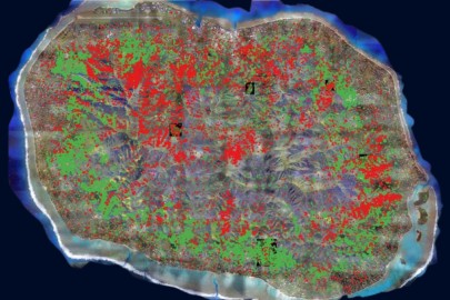
This map shows the distribution of the invasive African tulip tree (red dots) and falcataria (green dots) across Rarotonga.
“We wanted to accurately map these two species using a multi-scale, multi-spectral approach so we started by commissioning satellite and aeroplane imagery over the entire island (70 sq km) and collecting a range of drone imagery over five smaller areas across the island,” says Paul.
Manaaki Whenua Remote Sensing Researcher Dr Andrew McMillan was with Paul in Rarotonga, and says the team tested various remote sensing techniques with the aim of developing practical solutions for Pacific Islands wanting to monitor their own weed control projects.
“The best method we found was to use an artificial intelligence model to map the weeds in 10 cm resolution aeroplane imagery at the island-scale using training data from drone imagery of the smaller areas to identify the weeds,” says Andrew.
As far as the team is aware, the project is the first time a detailed multi-scale approach has been used to accurately map invasive weeds over a large area.
The map the team produced showed that there are approximately 10,500 flowering African tulip trees (22,000 in total because only 48% were flowering), and 12,000 falcataria trees on Rarotonga – covering 8.3% of the entire island.
When the team presented these findings in Rarotonga at a recent conference, locals were shocked at the extent of the invasion. “They knew that the weed invasion was bad but seeing the map really highlighted the true extent of the distribution and spread,” says Paul.
The imagery collected by Paul and his team can also be used to track the progress of natural enemies.
“A gall-forming mite (Colomerus spathodeae) and leaf-mining flea beetle (Paradibolia coerulea) have recently been released onto Rarotonga by Manaaki Whenua to help control the African tulip tree, and we are hoping to measure their impacts over the coming years,” says Paul.
The multi-scale imagery collected allows them to zoom in from an island-scale tree map to a leaf-scale natural enemy damage assessment.
“This is a unique approach that allows land managers to monitor not only changes in vegetation extent but also the severity of natural enemy impacts, especially in treetops that are otherwise inaccessible,” says Paul.
The team hopes other Pacific Islands adopt this approach and collect similar baseline imagery.
About this work:
Manaaki Whenua is the technical lead for the Natural Enemies - Natural Solutions Programme (PRISMSS). PRISMSS is a coordinating mechanism designed to facilitate the scaling up of operational management of invasive species in the Pacific.
The programme brings together experts to provide support within the Pacific region with a focus on protection of indigenous biodiversity and ecosystem function and provides a comprehensive suite of support services in a cohesive, effective, efficient, and accessible manner to Pacific Island countries and territories.
