How data science can shape tree modelling for sustainable land management
Funded through the Ministry of Business, Innovation and Employment, MBIE, and Singapore Data Science Consortium (SDSC), the Bridging the gap between remote sensing and tree modelling with data science programme has developed methods that are already underpinning projects. These include mapping tasks in urban and native forest environments on tree species identification and large-scale vegetation mapping of entire regions in AoNZ.
Manaaki Whenua senior researcher Dr Jan Schindler says that as well as new ways of detecting trees from aerial imagery and 3D LiDAR point clouds, researchers also developed novel deep-learning approaches, and were able to draw connections between data science, urban trees and wellbeing.

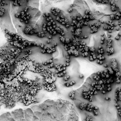
Aerial imagery of the Hawke’s Bay region that shows layers of objects classified into at least 5 vegetation classes: forests, standalone trees, shelter belt and riparian wetland down to the smallest detail.
“The developed methods have already found their way into practical applications by enabling and supporting new research and commercial projects,” says Jan.
Singapore, the ‘City in a Garden’, embodies the ‘green city’ concept with more than 7 million urban trees covering 700 km2, and New Zealand, with 24% of its 270,000 km2 land covered in forest, both actively support and promote urban re-greening in many of their cities.
“Sustaining and enhancing biodiversity and healthy living environments are priorities for Singapore and New Zealand that require careful management of trees in urban areas and forests, but this is often limited by the quality of available data, tools, and techniques to inform management decisions,” says Jan.
The research project successfully translated state-of-the-art AI technologies into practical outcomes for stakeholders. “We strengthened collaborative relationships among all New Zealand and Singapore teams, expanded our network to include external partners, and fostered the growth of a new cohort of researchers in the field of AI and remote sensing by leading over 23 student projects (PhD, BSc/MSc) in New Zealand and Singapore,” he adds.

Processing LiDAR tiles can extract detail at very fine scales.
To date, the programme has published 12 journal articles, nine conference proceedings and delivered over 15 conference talks with wmany collaborations continuing in the future.
“Over the past four years, we have developed novel data-science methods for extracting tree species information from petabytes of multi-resolution remote-sensing data to model tree species and their interactions with the environment, and subsequently analyse their socio-economic impacts,” says Jan.
Thanks to the cultural support of and exchange with Taranaki Whānui ki Te Upoko o Te Ika and Ngāti Maru, facilitated by Kiri Reihana, the researchers gained important insights into how this research can support iwi aspirations in current and future land management practices through several interactive hui in Wellington and with Ngāi Tai iwi in Eastern Bay of Plenty.
Jan says working with such a diverse group of scientists from different fields and organisations is fascinating and provides an opportunity to help understand how this work can have impact at research, government and commercial level. The programmes included research teams from Manaaki Whenua, Te Herenga Waka—Victoria University of Wellington, Te Whare Wānanga o Waitaha — University of Canterbury, Scion, Institute of High Performance Computing / A*STAR and Nanyang Technological University, Singapore.
“Even though we work on the same topics, everyone comes in from a different angle and words can have a different meaning, so it was really important to build personal relationships and come together for joint workshops in New Zealand and Singapore,” he says.
This project was supported by the Catalyst: Strategic Fund from Government Funding, administered by MBIE and was New Zealand’s largest ever single investment in a bilateral science programme.
The $11-millon NZD investment aimed to accelerate the development of data science capability in both countries and supported the collaboration between a wide range of New Zealand research institutes and leading Singapore researchers across several priority areas. These include health, natural language processing, and 3D temporal-spatial sensing of the environment.