- Home
- ...
- Smarter Targeting of Erosion Control (STEC)
- Smarter Targeting of Erosion Control (STEC) News
Applications of shallow landslide susceptibility and connectivity models for land-use planning and erosion control
These models are supported by papers published in international scientific journals (see references below) that describe the underpinning research. Articles in previous STEC newsletters covered much of this research in detail.
In this final article we focus on applications of these models to inform land-use planning and the targeting of erosion control (e.g. tree planting) to reduce the future occurrence of shallow landslides. We have seen growing interest from land managers and policy specialists in applying these models for farm- and regional-scale planning.
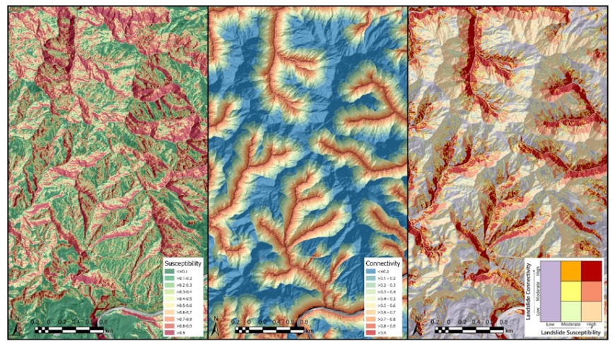
Recent examples of applications include modelling to understand the extent to which individual trees in pastoral areas prevented shallow landslides during Cyclone Gabrielle in Hawke’s Bay (Tsyplenkov & Smith 2024a). We also applied our models to produce high-resolution maps of shallow landslide susceptibility for the Hawke’s Bay region (Smith et al. 2024), as well as maps of landslide susceptibility and connectivity for the Gisborne region (Smith 2023; Tsyplenkov & Smith 2024b). The maps can be used at the forest or farm scale (Figure 1) to inform owners and managers of how susceptibility to landslides varies across their properties, and to assist in planning management actions.
We have also applied semi-automated mapping techniques to acquire spatial data on landslides and debris deposits from high-resolution satellite and aerial imagery following storm events (Betts et al. 2023). This targeted capture of landslide data can be used to update susceptibility and connectivity models to support regional applications.
A key feature of recent model applications has been the use of digital elevation models (DEMs) derived from regional LiDAR coverage. LiDAR-derived DEMs are a game changer for landslide susceptibility and connectivity modelling. The improved representation of topographic form, and slope angles in particular, leads to significant improvements in model performance and higher-resolution maps of landslide susceptibility and connectivity. For example, in an earlier STEC Newsletter article we reported that the use of a 5 m LiDAR-derived DEM increased the classification accuracy of the landslide susceptibility model from 72% to 88% compared to results based on the national 15 m DEM.
Cyclones Hale and Gabrielle hit the North Island when the STEC programme was in its final year. As a result we were able to support the response to these events by providing high-resolution landslide susceptibility maps to several councils. Without the research in STEC, this, and subsequent model applications, would not have been possible.

Figure 1. Examples of layers produced from our shallow landslide susceptibility and landslide-to-stream connectivity modelling (left to right): landslide susceptibility (probability scale), landslide-to-stream connectivity (probability scale), and a combined, class-based map of susceptibility and connectivity.
Recent applications
Betts H, Smith HG, Neverman A, Tsyplenkov A 2023. Wairoa shallow landslide and debris deposit mapping following storm events in March 2022. Manaaki Whenua – Landcare Research Contract Report LC4331, prepared for Hawke’s Bay Regional Council.
Smith HG 2023. Rainfall-induced shallow landslide susceptibility V1.0 layers for Gisborne. Memorandum accompanying GIS layers, 17 August 2023. Prepared for Gisborne District Council.
Smith HG, Neverman A, Betts H, Herzig A 2024. Improving understanding and management of erosion with LiDAR. Manaaki Whenua – Landcare Research Contract Report LC4466, prepared for Hawke’s Bay Regional Council.
Tsyplenkov A, Smith HG 2024a. Assessing the effectiveness of trees for landslide mitigation in Hawke's Bay. Manaaki Whenua – Landcare Research Contract Report LC4479, prepared for Hawke’s Bay Regional Council.
Tsyplenkov A, Smith HG 2024b. Morphometric landslide-to-stream connectivity layers for Tairāwhiti. Memorandum accompanying GIS layers prepared for Gisborne District Council, 12 March 2024.
International journal publications on rainfall-induced shallow landslides
Phillips C, Betts, H, Smith HG, Tsyplenkov A 2024. Exploring the post-harvest ‘window of vulnerability’ to landslides in New Zealand steepland plantation forests. Ecological Engineering 206: 107300. https://doi.org/10.1016/j.ecoleng.2024.107300
Phillips C, Hales T, Smith HG, Basher L 2021. Shallow landslides and vegetation at the catchment scale: a perspective. Ecological Engineering 173: 106436. https://doi.org/10.1016/j.ecoleng.2021.106436
Smith HG, Neverman AJ, Betts H, Spiekermann R 2023. The influence of spatial patterns in rainfall on shallow landslides. Geomorphology 437: 108795. https://doi.org/10.1016/j.geomorph.2023.108795
Smith HG, Spiekermann R, Betts H, Neverman AJ 2021. Comparing methods of landslide data acquisition and susceptibility modelling: examples from New Zealand. Geomorphology 381: 107660. https://doi.org/10.1016/j.geomorph.2021.107660
Spiekermann RI, McColl S, Fuller I, Dymond J, Burkitt L, Smith HG 2021. Quantifying the influence of individual trees on slope stability at landscape scale. Journal of Environmental Management 286: 112194. https://doi.org/10.1016/j.jenvman.2021.112194
Spiekermann RI, Smith HG, McColl S, Burkitt L, Fuller IC 2022. Development of a morphometric connectivity model to mitigate sediment derived from storm-driven shallow landslides. Ecological Engineering 180: 106676. https://doi.org/10.1016/j.ecoleng.2022.106676
Spiekermann RI, Smith HG, McColl S, Burkitt L, Fuller IC 2022. Quantifying effectiveness of trees for landslide erosion control. Geomorphology 396: 107993. https://doi.org/10.1016/j.geomorph.2021.107993
Spiekermann RI, van Zadelhoff F, Schindler J, Smith HG, Phillips C, Schwarz M 2023. Comparing physical and statistical landslide susceptibility models at the scale of individual trees. Geomorphology 440: 108870. https://doi.org/10.1016/j.geomorph.2023.108870
Key contacts

