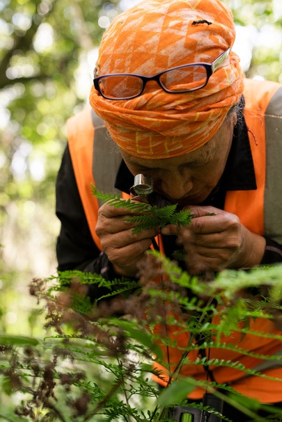
Margaret Ngārimu (Whareponga) identifying ferns at the Rākaukākā forest site. Margaret’s rich wealth of knowledge of flora and fauna in Te Tairāwhiti was invaluable to the fieldwork
This is how Mere Tamanui (Te Aitanga a Hauiti) describes the devastating impacts Cyclone Gabrielle had on lowland native forests in Te Tairawhiti / Gisborne.
The danger of losing these forests and taonga species due to climate change and an increase in extreme weather events such as Cyclone Gabrielle has sparked new partnerships between local kaitiaki and Manaaki Whenua – Landcare Research scientists.
The goal is simple – to understand forest fragments and protect the region’s precious biodiversity.
Manaaki Whenua Plant Community Ecologist Dr Warwick Allen and Senior Technician Plant Ecology Paula Godfrey (Ngapuhi, Ngati Whatua o Kaipara, Ngati Whakaue) recently led a team who partnered with local mana whenua and landowners to establish 41 permanent monitoring plots in 19 floodplain forest fragments between Wairoa and Whareponga.
Forest fragments, small patches of precious native forest, have their own unique threats and management needs because of their small size, isolation from other forests, and the range of activities that occur on the land around them.
Extreme weather events have caused disturbance in North Island lowland forests for millennia, such that many of their plant species could be considered ‘flood-adapted’, like the towering kahikatea (Dacrycarpus dacrydioides), sub-tropical pukatea (Laurelia novae-zelandiae), and nationally vulnerable heart-leaved kohuhu (Pittosporum obcordatum).
However, the natural process of forest regeneration after these weather events now faces pressures such as increased sediment deposition (a result of historical clearance of native forest for pasture and plantation forest), browsing by stock and feral animals, and invasive weeds.
“Without management to mitigate these pressures, regeneration may be disrupted or prevented entirely, meaning that we are in danger of losing the few lowland forest fragments that remain in Te Tairawhiti,” says Warwick.
The team aimed to quantify damage to lowland forests from Cyclone Gabrielle and assess whether management practices such as fencing and weed control promote regeneration after disturbance from extreme weather events.
“It was confronting to see how the cyclone had impacted some of the forest fragments. Many trees were dead or dying in some of the worst-affected areas,” says Warwick.
“However, at other sites I was left feeling hopeful by the presence of a diverse and healthy understory with various sizes of seedlings and saplings, suggesting that regeneration is possible with appropriate management.”
Monitoring in action
The monitoring sites were chosen through discussion with local ecologists and kaitiaki, including Malcolm Rutherford (QEII National Trust), Don McLean (Gisborne District Council), Mere Tamanui (Te Aitanga Hauiti), Damian Whaanga (Rongowhakaata Iwi Trust), and Margaret Ngarimu and Jade Gibson (Whareponga).
Margaret Ngarimu (Whareponga) identifying ferns at the Rakaukaka forest site. Margaret’s rich wealth of knowledge of flora and fauna in Te Tairawhiti was invaluable to the fieldwork.
At each forest fragment, the team established up to three permanent 20 x 20 metre monitoring plots.
In each plot, they measured cyclone damage (sediment depth, flood height, and tree survival), characterised the plant community (plant species identity and percent cover), and quantified potential for forest regeneration (seed bank composition, seedling and sapling counts, browsing mammal signs).
Partnering with kaitiaki

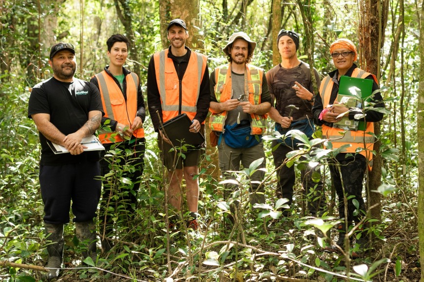
Partnering with kaitiaki: The team spent a day with Rongowhakaata Iwi Trust at Rākaukākā Forest, where they provided training in the permanent plot method. Pictured (from left): Kevin Hare (Rongowhakaata), Paula Godfrey, Dr Warwick Allen, Paul Robbins (Manaaki Whenua), Damian Whaanga (Rongowhakaata) and Margaret Ngārimu (Whareponga).
Warwick and Paula worked closely with mana whenua, landowners, and engaged with local kura (schools) to establish the monitoring sites.
The team spent a day with Rongowhakaata Iwi Trust at Rakaukaka Forest in Manutuke (near Gisborne), where they provided training in the permanent plot method. The land has felt the impacts of multiple cyclones and is facing pressures from surrounding land use, including sediment deposition and invasive weeds.
Not only did flooding from Cyclone Gabrielle reach almost 2 m and deposit up to 12 cm of sediment but, in 1990, Dr Bev Clarkson (recently retired from Manaaki Whenua but an ongoing Research Associate) found that Cyclone Bola (1988) had deposited over 1 m of sediment in some parts of the forest.
Rongowhakaata Iwi Trust Taiao Team Lead Damian Whaanga (Rongowhakaata, Ngati Kahungunu) says it’s great meeting and working with people who are dedicated to learning and exploring.
“I could feel everyone’s passion for a bigger kaupapa (project). It doesn’t feel like work when you are vibing together.
“Relationships are important to me, with the taiao (environment) and with people. In this mahi you can harmonise the two.”
Rongowhakaata Iwi Trust Taiao team member Kevin Hare (Rongowhakaata, Ngai Tamanuhiri) says the knowledge shared by Manaaki Whenua through this project has significantly contributed to their growth, particularly in plant identification.
“For us, this mahi holds deep significance,” says Kevin. “Our whenua and taonga species are central to our identity and well-being. The recent devastation caused by extreme weather events has highlighted just how critical it is to protect and restore our natural environment. “Being part of this work ensures that we are not only safeguarding our whenua but also upholding the values and responsibilities passed down through our whakapapa.”
Jade Gibson and Margaret Ngarimu (Whareponga) helped the team facilitate site access and relationships in their beautiful rural community, Whareponga, just north of Waipiro Bay.
“This wasn’t just about data collection or setting up permanent plots — it was about building a relationship, one that I hope will be long-lasting and genuinely reciprocal,” says Jade.
“The purpose of the project was to understand how Cyclone Gabrielle might impact the natural regeneration of our precious kahikatea stands. For me, as tangata whenua, this felt like more than research — it was an opportunity for our whanau to connect more deeply with our ngahere and to understand how we can best carry out our role as kaitiaki in our lowland kahikatea stands.”
Mere Tamanui (Te Aitanga a Hauiti) has links to many projects throughout the region and helped facilitate access to sites in Ūawa / Tolaga Bay.
She said the devastation Cyclone Gabrielle caused to their whenua was staggering.
“It was like a blanket of sediment suffocated our vulnerable taonga species, with 80- to 100-year-old freshwater mussels ploughed up by turbidity and dumped on riverbanks. The cyclone deposited over two foot of sediment in some areas and shifted our saltwater wedge due to the riverbed build-up,” says Mere.
“This project has given us tools and skills to gather information to help validate our natural observations and provide a record of impacts and recovery in the face of climate change,” she says.

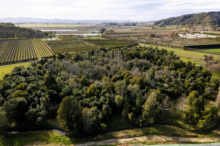
The Rākaukākā Forest in Manatūkē, Gisborne, is managed by the Rongowhakaata Iwi Trust and filled with a beautiful canopy of taonga species. This forest fragment was impacted by Cyclone Bola in 1988 and Cyclone Gabrielle in 2023.
Next steps, results, and recommendations
Warwick and his team hope to release initial results from the monitoring later this year, as well as supporting iwi and other groups to expand on this forest monitoring.
“We aim to resurvey the plots in 5-10 years to evaluate long-term impacts and post-cyclone recovery and regeneration. A key benefit of permanent monitoring plots is that they allow us to assess change over time.”
In the meantime, Warwick suggests landowners look to fence and manage weeds in any remaining lowland forest fragments.
“We recommend fencing forest fragments to prevent stock and animal access and promote regeneration.
“Stock access means that almost no saplings are coming through to replace mature trees, because seedlings are munched or trampled before they even have a chance.”
However, excluding stock and animals could encourage growth of weeds, so regular weed control is also required in any forest that has been fenced.

